BP-32 Recorder Specification |
|
|---|---|
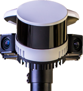
Cameras |
|
| Number of cameras | 4 |
| Single sensor resolution | 2448 px x 2048 px |
| Pixel size | 2.74 μm x 2.74 μm |
| Lens focal length | 2.5 mm |
| Aperture | F2.4 |
| Panorama coverage | 360° x 180° |
| Panorama resolution | 12 MP |
| Image format | JPEG |
| Image frequency | 2 Hz |
| Synchronization accuracy | ~1 μs |
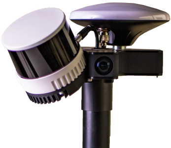
LIDAR / SLAM |
|
| Field of view (horizontal / vertical) | 360° / 40.3° |
| Number of laser beams | 32 |
| Data rate | 640,000 points/sec |
| Rotational frequency | 20 Hz |
| Scanner range | 0.5 – 300 m |
| Inclination angle | 45° |
| Resolution (horizontal / vertical) | 0.18° / 1.25° |
| Time synchronization | < 1 μs |
Accuracy and Point Cloud Format |
|
| Device position accuracy | 1.5 – 2 cm |
| Point cloud position accuracy | 2 cm |
| Point cloud format | Binary LAS 1.2, X,Y,Z, Intensity, Reflectivity, RGB |
| Colored point cloud | Yes |
Inertial Measurement Unit |
|
| Sampling frequency | 1000 Hz |
| Bandwidth | 100 Hz |
| Gyroscope |
Dynamic range: ±250°/s, Bias instability: 0.09 °/√h, Angle random walk: 1.9°/h |
| Accelerometer |
Dynamic range: ±2g, Bias instability: 5–12 µg, Velocity random walk: 0.011 m/s/√h |
| Sampling synchronization | ~1 μs |
GNSS Receiver |
|
| Constellations | GPS, Galileo, BeiDou, GLONASS |
| Frequency | 10 Hz |
| Channels | 184 |
| GNSS antenna | Multi-band survey GNSS antenna |
| RTK | Yes |
| NTRIP base station | Optional |
Processing Unit |
|
| Processor | Quad-core |
| RAM | 2 GB |
| USB 3.0 drive | 128 GB |
| Communication | Wi-Fi |
Power Supply |
|
| Battery capacity | 150 Wh |
| Voltage | 15 V |
| Operating time | ~4 h |
| Full charge time | ~3 h |
| Replaceable battery | Yes (additional battery available) |
| Charger included | Yes |
Operating Environment |
|
| Operating temperature | -10° to 40° C |
| Water resistance | No |
Weight and Dimensions |
|
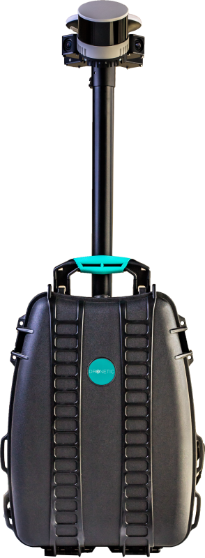
| Height / length / width | 105 / 32 / 38 cm |
| Weight | ~10 kg |
Control |
|
| Remote control | Smartphone with Internet access |
| Stationary control | Measurement can be started with a button |